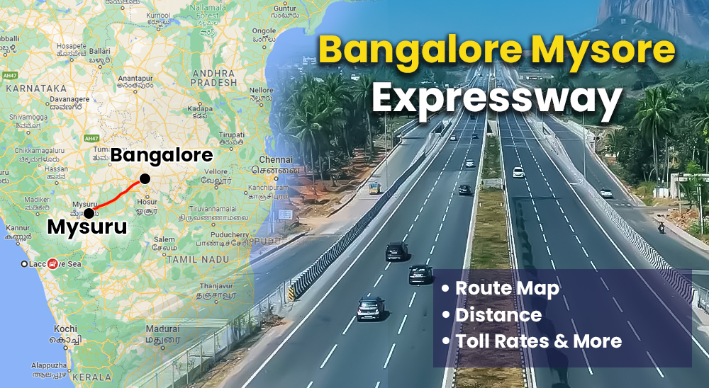
Bangalore Mysore Expressway: Distance, Map, Route, Toll Rates & More
Bangalore Mysore Expressway has been developed in a whopping amount of Rs 8066 crore. The total distance between both cities is 3 hours which will be reduced to 90 minutes. Bangalore Mysore Expressway has been designed to connect major cities Kodagu, Mangaluru, and Kerala regions. The expressway is 117 km long and the permissible speed limit is 80 lm/h and 100km/h. In this project, we have discussed the details related to Bangalore Mysore Expressway, distance, advantages etc.
Bangalore to Mysore Distance
The major aim of constructing the Bangalore Mysore Expressway was to reduce the overall time to cover both cities to 90 minutes. There are three routes to cover the expressway i.e. rail, road and flight. Here are the major details related to the same.
| Mode of Travel | Distance | Total Time |
| Road | The distance between the two cities can be covered by two roads around 144 km (90 miles) via NH275 and around 160 km (99 miles) via NH948. NH 275 is the quickest and most efficient way to get from Bangalore to Mysore | 4 hours |
| Rail | MGR CHENNAI CENTRAL-MYSURU SHATABDI EXPRESS | 2 to 5 hours |
| Flight | Kempegowda International Airport Mysore Mandakalli Airport | 2 hours |
Bangalore Mysore Expressway Key Details
Refer to the table below to learn about the major key details related to the Bangalore Mysore Expressway.
| Particulars | Facts |
| Project cost | Rs 8,066 crore |
| Project length | 119 km |
| Developed Under | BharatMala Project |
| Start point | Bengaluru |
| Endpoint | Mysore |
| Number of lanes | Four can be expanded to eight if required |
| Deadline | March 2023 |
| Current Status | Land acquisition and financial bid evaluation |
| Developer of the project | National Highways Authority of India (NHAI) |
| States covered | Bengaluru, Mysore, Kerala, Kodagu, and Mangalore |
| Project model | Hybrid Annuity Model |
| Underpasses/flyovers | Underpasses: 41 Flyover:17 |
| Speed limit | 120km/hr |
Bangalore Mysore Expressway Progress
The Bangalore Mysore expressway project was proposed to be developed by the NHAI in 2014. The competent authorities announced that the work on the project will commence in two phases in May 2019 and December 2019. However, the expressway was halted due to COVID-19 and the project became operational in March 2023.
Bangalore Mysore Expressway Route Map
Bengaluru Mysuru Expressway is going to be a greenfield bypass with a 22 km bypass for Ramanagaram and Channapatana combined, an 8 km bypass for Mandya, a 10 km bypass for Srirangapatana, and a 4 km bypass for Maddur. There will be also enough space for 69 bus bays, 49 underpasses, 13 overpasses, and fencing on either side of the access-controlled, 6-lane roadway to provide a free and uninterrupted trip. Here is the detailed route map for the expressway.

Advantages Of The Bengaluru-Mysuru Expressway
The Bangalore Mysore highway once operational will offer the following advantages and benefits to the people residing beside it.
- The Bengaluru Mysore Expressway will reduce the distance between both cities to 90 minutes
- The expressway will be extremely beneficial for the real estate of the city
- The expressway is going to accelerate the city’s development and growth of the area
- The construction of 59 over and underpasses will lessen traffic congestion and provide road safety
Bengaluru-Mysuru Expressway: Phases
Bengaluru Mysuru Expressway is divided into two phases both have separate lengths along with separate costs. The total project cost is Rs 3900 crores and comprises of 44 small bridges, 19 large bridges, and 44 micro bridges. The details related to both phases can be checked in the section below.
| Phase Type | Connectivity | Total Cost | Project Length |
| Phase 1 | Bangalore and connects Panchamukhi Ganapathi Temple on NICE Road to Nidaghatta | Rs 1600 crore | 56.2 km |
| Phase 2 | Nidaghatta to Mysore | Rs 1200 crore | 61.1 km |
Toll And Rates For The Bengaluru-Mysuru Expressway
The toll rates for the Bengaluru Mysuru Expressway are prescribed by the NHAI. The standard toll charges for the expressway range from Rs 200 to Rs 250. However, this is fixed upto 60 kms only. After this distance is covered, one will be required to pay Rs 1.5 to Rs 2 per km. Go through the table below to learn about the latest tolls and rates for the Bengaluru Mysuru Expressway.
| Type of Vehicle | One Way Trip | Return Trip |
| Cars/SUVs/Vans | Rs 155 | Rs 255 |
| LCVs/LGVs/Minibuses | Rs 235 | Rs 375 |
| Trucks/Buses (2 Axles) | Rs 525 | Rs 790 |
FAQs
- How much toll charge from Bangalore to Mysore?
Ans. The toll charge from Bangalore to Mysore ranges from Rs 200 to Rs 790.
- What is the total cost of Bangalore Mysore highway?
Ans. The total cost of Bangalore Mysore highway is Rs 8066 crores.
- How much does the expressway cost from Mysore to Bangalore?
Ans. The expressway cost from Mysore to Bangalore costs only Rs 8066 crores.
- Which project has helmed the Bangalore Mysore highway?
Ans. The Bangalore Mysore highway is been developed under the BharatMala Expressway.
- How toll charges are calculated?
Ans. The toll charges on the Bangalore Mysore highway are capped at Rs 250 for only upto 60 km. Post this, one has to pay the changes based on the distance travelled by them.